Top Warning Information Unavailable, error fetching or reading data from the NOAA advisories server.


METRIC | IMPERIAL
Updated: 08-May-2024 @ 4:55am  
Temperature Current Conditions Forecast / Storm Prediction
Currently Outside: Colder 1.1°F than last hour.

33.2°F

Wind Chill:  33.2°F
Cold
High Today
38.8°F
12:00 AM
Low Today
33.2°F
4:50 AM
Yest High
57.6°F
3:51 PM
Yest Low
38.8°F
11:58 PM
Sta* High
80.4°F
2018
Sta* Low
33.6°F
2010
* This Station's Records Since 02/2008
Station Record Low
<!-- fixupCondition in='Night time/Dry/Clear skies ' out='Night time, Dry, Clear skies' ocnt='3' --><!-- vals split on slash -->
Night time, Dry, Clear skies Night time, Dry, Clear skies

Calm Wind:  NNE
0.0

Gusting to:
0.0 mph
Current Rain Rain:
0.00 in
Chandler Burning Index: LOW Current CBI
Fire Danger:
-2.4 of 100
Overnight

Overnight: Partly Cloudy
Partly Cloudy
Wednesday

Wednesday: Mostly Sunny
Mostly Sunny
Wednesday
Night
Wednesday Night: Mostly Clear
Mostly Clear
Lo 38 °F Hi 65 °F Lo 43 °F
North Bend Web Cam
Dew Point Liquid Precipitation Wind Speed Sun/Moon
Current: Decreased 1.1°F since last hour. 31.9°F
Last Hour: Decreased 1.1°F since last hour. 1.1°F
High 12:00 AM: 36.9°F
Low 4:50 AM: 31.9°F
Record High: 80.6°F on
27-Jun-2021
Record Low: -0.0°F on
13-Jan-2024
Wetbulb: 32.7°F
Rain Today
rain graph

Today: 0.00 in
Storm Rain: 1.09 in
Yesterday: 0.19 in
Last 7 Days: 1.09 in
May Rain: 1.09 in
May to Date
  Avg:10
1.09 in
May to Date
  Diff from Avg:10
No Change 0.00 in
May Avg: 3.62 in
Diff from Avg: Under 2.53 in for the month 2.53 in
Season:1 25.49 in
YTD
  Avg:11
28.03 in
YTD
  Diff from Avg:11
Under 2.54 in for the year 2.54 in
Last Rain
Time/Date:
7-May-2024
at 1:29 PM
83 rain days in 2024
4 days in May
0 days since last rain
Current: NNE  0.0 mph
1Hr Average: Calm
Wind Run: 0.13 miles
Wind Gust
Current: 0.0 mph
Today: 3.5 mph 1:31 AM
Month: 25.0 mph 5-May
Year: 43.0 mph 8-Jan
Record Gust: 57.0 mph
13-Nov-2015
Sunlight:
14 hrs 50 min
of Sunlight Today
graph 61.8% 38.2%
Which is
2 min 47 sec Longer
Than Yesterday
 
NEW MOON, 0 days, 8 hours, 35 minutes in cycle
0%
Illuminated
Humidity Barometer
Current: No Change 95%
Last Hour: No Change 0%
High 3:16 AM: 95%
Low 12:00 AM: 93%
Record High: 100%
14-Jan-2012
Record Low: 0%
21-Nov-2020
Current: Rising 0.008  inHg/hr 30.399 inHg
Last Hour: Steady
High 4:32 AM: 30.401
Low 12:00 AM: 30.350
Record High: 30.838 inHg
30-Dec-2014
Record Low: 28.857 inHg
27-Dec-2022
Heating Degree Days Tide Wind Chill
Today: 5.2
May: 107.4
2024 to Date: 2531.0
Cooling Degree Days
2024 to Date: 0.0

6 hours, 54 minutes to low tide at
11:51 AM PDT


Current: 33.2°F
Low 4:50 AM: 33.2°F
Yesterday: 38.1°F
Record: -3.8°F
13-Jan-2024
UV Summary/Forecast Solar Summary
High Yest:    @ 11:52 AM
May-08

May-09

May-10

High Yest:   1125.2 @ 12:22 PM
Sun Hours Today:
00:00
   This Month: 72:12 Hrs
Rise: 5:38 am  Set: 8:28 pm
Almanac Irrigation Index5 Station All Time Records Cloud Level
Currently: Early Morning
YTD Avg Temp: 45.2°F
Sunrise: 5:38 am
Sunset: 8:28 pm
Moonrise: 5:39 am
Moonset: 8:26 pm
Full Moon: May--2024
New Moon: 12:38 UTC
June--2024
Updated at Midnight
Current ET: 0.01 in
7-Days Rain: 1.09 in
7-Days ET: 1.09 in
7-Day:  0.003 in water in excess of what evaporated in last 7 days. 0.003 in
May: No Change 0 in
Support this Site!
Your donation helps support this site
HIGHS: LOWS:
109.6°F
29-Jul-2009
9.7°F
23-Nov-2010
Daytime Records
  107.1°F
28-Jun-2021
  17.6°F
12-Jan-2024
Nitetime Records
  86.5°F
30-Jul-2009
  11.8°F
24-Nov-2010
ICN:1 | S3C2:2 | Ajax 3.07
ISS:Ok | CON:4.7 | RCP:88%
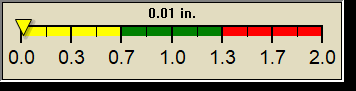
1 Rain season: Jan 1st to Dec 31st.   5 Estimated amount of water needed to replace the water used by plants and evaporation from the past week. (Negative numbers mean amount of water needed, positive numbers mean excess water is present).   10 Historical average only to day 8 of just the month of May for this station since 2008.   11 Historical average rain this season to day 8 of May for this station since 2008.
 NWS Weather Forecast  -   Outlook Overnight & Wednesday
Overnight

Overnight: Partly Cloudy
Partly Cloudy

Lo 38 °F
NWS forecast: Partly cloudy, with a low around 38. Southwest wind around 2 mph.
Local station forecast: Partly cloudy with little temp change.
Wednesday

Wednesday: Mostly Sunny
Mostly Sunny

Hi 65 °F
NWS forecast: Mostly sunny, with a high near 65. Northwest wind 2 to 7 mph.


Countdown to Summer
 Summer Solstice begins June 20th at 1:51pm   PDT